


GPS software and FS
GPS in FS2004
A few years ago the idea of using any real flying equipment in FS was unthinkable. This is now changing as the boundaries between the two slowly draw together. Aircraft design has improved so much that real world checklists need to be used for some aircraft. Scenery has become so detailed that you can now use real charts for cross country flying - and can even use real world planning techniques and equipment to create an FS flight plan.
Then Peter Dowson came up with a small utility called GPS Out for FS2004. This converts FS flight data into an NMEA format that most GPS units use so, plug a GPS unit into your PC and next thing your FS2004 position is being displayed on the GPS.
GPS without the hardware
The above is all very well for the few of use who have such equipment and you may be wondering about reading on - but please do. The essential thing for FS users is that FS2004 output is actually mimicking a GPS unit so all you need is the receiving software - and this can be on a PC or PDA aswell as a GPS unit.
Here is a flow chart of the testing I have just carried out with both FS2004 and my other applications.
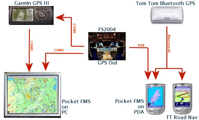
As you can see I was able to do the following:
1.
Export FS2004 "GPS" data to my PDA. (via USB)
2. Export FS2004 data to my Garmin unit. (via a COM port)
3. Export FS2004 data to GPS software on my PC. (via COM port)
4. Export Garmin GPS data to GPS software on my PC (via COM port). Not
much use but a laptop is a different matter.
5. Send data from a GPS Bluetooth unit to GPS software on my PDA.
Software rules - OK?
GPS software for real world use is excellent when coupled with FS2004. There are many GPS software programs to be found and these range from full GPS emulators to moving map displays. For these tests I tried one of each - Pocket FMS and Memory Map. I'll describe both later in this article.
The essential software for FS2004 users is GPS Out. A small utility (only 10k) for FS2004 from Peter Dowson (of FSUIPC fame).
The GPS software you then need to connect to is of your own choice. I will primarily talk about PocketFMS because it is free to download and use.
GPS Out
GPSOut is available from http://www.schiratti.com/dowson.html
This is a very simple little program that converts FS2004 data to NMEA format and can send it to a good number of GPS software programs. These include:
Pocket
FMS
Garmin GPS units
AutoRoute 2001
AutoRoute Express 98
Anywhere Map, by Control Vision
MapPoint 2001
Map'n'Go
FliteMap
Memory Map
GPS Out has two files which should be copied to your FS2004/Modules folder. These are GPSOUT.DLL and GPSOUT.INI.
The INI file needs to be set up correctly for the hardware you are using. This can be tricky so read the following carefully.
The GPSOut.INI file must be edited (Notepad is best) to set the correct values for your PC, PDA and software. Below are the values I use - together with comments about possible variations.
|
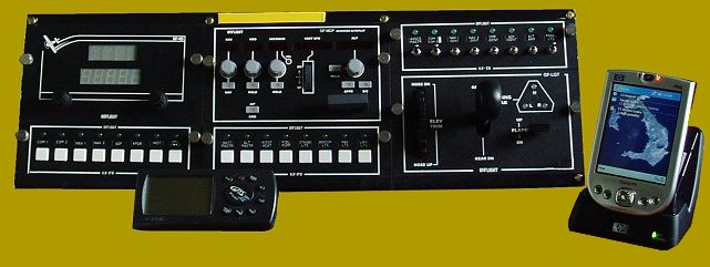
GPSOut to Garmin GPSIII Pilot unit (shown above running from FS2004)
[GPSout] On the Garmin I changed the Interface settings to Aviation In so it would pick up the GPSOut data through the cable on COM1. Note:
The above values worked on my old PC which had serial and parallel
ports on the mobo. When I upgraded to a new USB only mobo with no
COM ports I had to install a serial card. After this was installed
the port was different and I had to change the port line to
Port=COM3 |
|
GPSOut to GPS software (Pocket FMS or Memory Map) on the PC
[GPSout] I forgot to change GPSOut to these values after having run FS2004 with my Garmin unit and I still got data through to Pocket FMS on the PC. Note:
Same as the note above - changing to a USB motherboard stopped this
working. Once the serial card was fitted it was fine again but if
you don't need a serial card I understand you can install a COM
port emulator. This may require changing the Port line - check the
docs. I now use COM3 for this option. |
GPSOut to GPS software on a PDA
The tricky one is setting GPSOut to work with GPS software (Pocket FMS or Memory Map) on a PDA.
The PDA connection to a PC is via a cradle and a USB port. Now it was thought that the serial output would not work from FS but, luckily, some clever chaps have found a way round this - although there seems to be no single setting that is universal. You may need to experiment . For my own setup I used the following lines:
|
GPSOut to GPS software on a PDA
[GPSout] Other users have used a different string for the Port line so you may need to experiment. A second one to try if the above fails to work is: [GPSout] Notice
there is no dot between the backslashes in the Port line. |
If you have a Bluetooth computer things are a lot easier because you can set up a virtual COM link directly with the PDA. In this case you can use the same settings as for Pocket FMS to your PC - just change the COM port to the one you have set up.
Note: Many modern computers no longer have any serial ports on the rear panel and this may cause problems. Indeed my new PC is USB only and, try as I might, I have not been able to get either the Garmin unit or Pocket FMS to find the data coming from GPSOut. This was finally fixed by inserting a serial card in the PC.
OK - that's about all you need to do with GPSOut so let us take a look at Pocket FMS next.
Pocket FMS
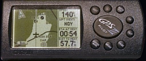
After years of staring at the small display on the GPS III Pilot it is a real pleasure to see a GPS readout on a bigger screen - and in colour! Compare the Garmin shot above to a PDA screen below (both shown at actual size) - the PDA gives you exactly double the display area.
Pocket FMS is a real world, aviation related GPS program. It works in exactly the same manner as the software on Garmin GPS units in that it shows your map location, warns you of airspace ahead, has databases for airfields, navaids, fixes and airspace for full flight planning and all the rest you would expect.
The software is good and, believe it or not, it is a free download with no time or feature locks in it. The software will install on your PC and if you have a suitable PDA it will copy a neater version to the PDA if you tell it to (by pressing the Synchronise button on the main map screen).
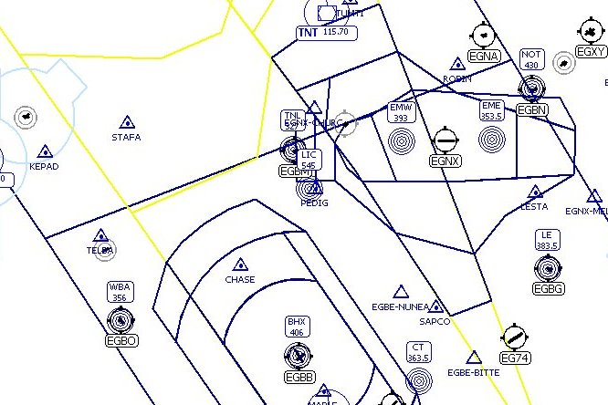
Here's a screen shot of the PC version in its full glory with navaid, map and terrain data switched on:
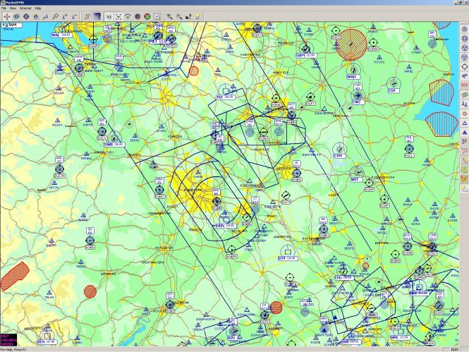
However the display is infinitely variable (I'll go into the maps in a bit more detail below) and you can switch it to almost any level you like. With just basic navaid data loaded the screen is much simpler:
PC Connection
To get Pocket FMS on your PC working with FS2004 is quite simple. Having set up your COM port in GPSOut all you need do is start Pocket PC first (I'll explain why in a moment) and position it to your liking on your monitor - or secondary display if you are that lucky. Go to the Properties menu, bring up the GPS Properties tab and set the COM port to the same you set in GPSOut.
Next start FS2004, choose your options and hit the Fly Now! button.
As soon as FS dumps you on the runway the GPSOut file will start sending out data BUT you must connect Pocket FMS fairly soon afterwards (about ten seconds) or else the datastream tends to get lost. To do this switch back to Pocket FMS and press the GPS Receiver button. A few seconds later and your aircraft should relocate to your FS position and you are in business!
PDA Connection
PDA connection is slightly trickier but should not be too difficult.
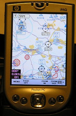
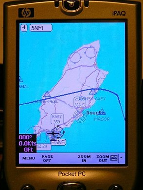
The shot above shows Pocket FMS running on my iPAQ 4150 and centred on Woodley NDB. This was before connecting to FS2004. Excuse the yellow cast in the shot but it was necessary to make the display more readable. The display shows Pocket FMS running with navaid and map data but not elevation data.
For connection to the PDA you must first change the settings in GPSOut so that data is sent from FS2004 to the USB bus. Having done that you must then set up the PDA by doing the following:
|
Close ActiveSync. If you don't do this ActiveSync hogs the connection and GPSOut will not work. In ActiveSync click on File and Connection Settings. Untick the box that says "Allow USB connections". Start Pocket FMS. Make sure "Ignore position fix" is checked in the Advanced PocketFMS settings. Start FS2004. Set up your flight and then stop just before hitting Fly Now! In Pocket FMS click on the Enable GPS button.
In FS2004 press Fly Now! |
In Pocket FMS the settings are normally on autodetect for baud and COM port. My setup doesn't like this but will connect if I set COM on Port 6. The actual COM port will differ for everyone do you may have to experiment with this setting.
If Pocket FMS doesn't find a signal on the selected COM port it will stop searching. You may have to press Enable GPS again if this comes up.
If you are lucky and Pocket FMS connects first time you will get a display similar to that below with the aircraft at your location and a readout showing height, speed and heading. There is no need to do much else with the software unless you like playing with the settings. It will show your position automatically and warn you when you are approaching controlled airspace.
|
|
|
|
|
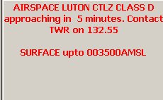
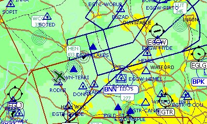
Above is an example of an airspace warning. I had been flying near the London TMA for a while at 3000ft and Pocket FMS had not said anything - but as soon as I turned towards airspace that I would penetrate I got a five minute warning.. I have not experimented with it yet but I understand the same applies if you are flying towards rising terrain that is less than 500ft below the aircraft.
The nice thing about the airspace warning is that regardless of how many other applications you may have running on top of Pocket FMS (and I have several as I write this) the airspace warning will punch through the lot and won't go away until you click on it. When you do so Pocket FMS automatically comes to the top of the programs on your screen.
Notes about Pocket FMS
I have to write this bit because Pocket FMS is a serious aviation application and its simple interface hides some complex bits of the program.
If you get Pocket FMS take time to read the manual - I can assure you it is worth it. Although I have only touched on the display part of the program it also includes sections for flight planning and aircraft performance, weight and balance and take off/landing distances. You are not likely to require these in FS2004 as you can still use the GPS provided in the sim for flight planning and autopilot if you wish. Pocket FMS is a passive program - it cannot take charge of a real aircraft or of FS2004. For the same reason you can still plan and fly using FSNav.
It is essential to read the manual to find out how to download the data to use with the program. You have to select your location (FIR) and then ask for the Map, Terrain, Meteo and Nav data to download before you see anything on screen. As you can gather the data is huge for the whole world so only choose those FIR's you really need. Every month PocketFMS will remind you to grab the most recent data so it is always up to date. As a guide:
Select only one FIR to begin with.
Set the map to Level 0.
Select the Internet option and get the Nav data for this area. Don't forget that this works at all zoom levels so you only have to grab it once.
Select the Map Data to download the mapping for Level 0.
Select Terrain data to download terrain mapping at Level 0.
This should not take too long and should get you started in Pocket FMS. If you would like further detail then set zoom to Level 1 and grab Map data for this level (fairly quick) and Terrain if you like pretty maps. The terrain data takes a bit longer to download for any level. At the moment I have this data up to Level 5 for the UK but at this zoom the detail is causing some seriously big downloads.
Almost home.
Memory Map
Memory Map is quite different to PocketFMS as it is not a GPS emulator but basic moving map software. The version I have contains the UK CAA 1:250,000 and 1:500,000 scale aeronautical charts plus most airfield diagrams. A separate installation gives me 1:50,000 OS maps for the whole of the UK.
It may be thought that moving map software is less useful than a full GPS program like PocketFMS but it is far better for pure VFR flying - map data in the PocketFMS is very limited. You could argue that PocketFMS is better for IMC flight and Memory Map best for VMC flight. Compare the shot below with the PocketFMS screenshot above.
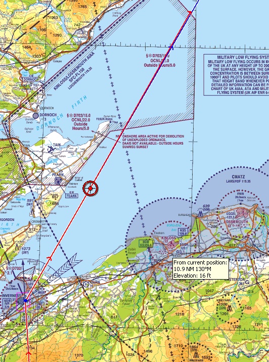
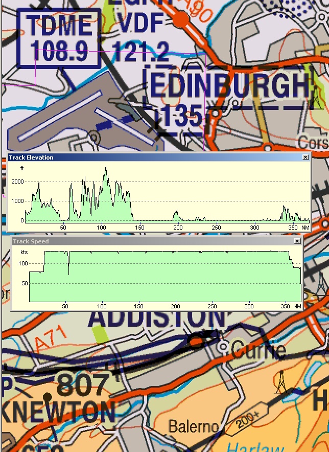
Memory Map has flight planning capabilities but you plot your route on the map as you would in real life. You could set up waypoints for navaids, airfields and fixes if wanted. In the screenshot above I had drawn a route from Edinburgh to Inverness and Wick and FS2004 had flown it from a similar plan made in FSNav. The red circle is the current position with the track flown also shown in red. Ahead of the aircraft is a leader line showing the next five minutes of flight and mostly obscuring the planned route in blue. I have since changed this leader line from red to green.
The mouse cursor will always give the distance and heading from your current position. Above the mouse was pointed at Kinloss showing a heading of 130M and distance of 10.9nm should I wish to divert there in a hurry. Memory Map can also show terrain profile of the route and speed, height profiles for the flight recorded. It can also zoom in to quite high level of detail.
Setup was identical to PocketFMS and, apart from the GPS connections jumping to virtual port COM9, it worked perfectly with FS2004 when connected to the PDA.
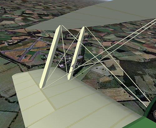
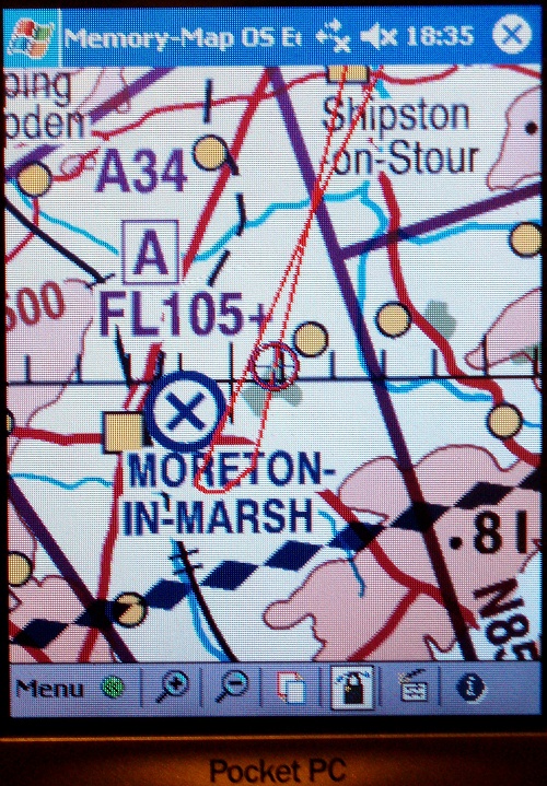
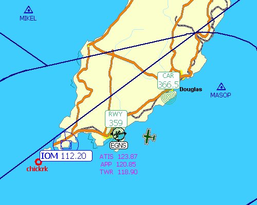
In the photo above of the PDA I approached the disused airfield at Moreton in the Marsh from the northeast and then made a left turn downwind - when I took the FS screenshot. This display is set to the half-mil map but you can change to quarter mil very quickly.