


UK Approach Minima
UK Approach Minima explained
Missed Approach Procedure and Decision Height/Minimum Descent Height
Let me start off with a graph to show the relationships of these confusing terms.
| Precision
Approach (ILS, MLS) |
Non
Precision Approach (Loc, VOR, NDB, SRA etc) |
|
|
Aircraft descends to - |
Decision Height | Minimum Descent Height |
|
Aircraft goes around at - |
Decision Height | Missed Approach Point |
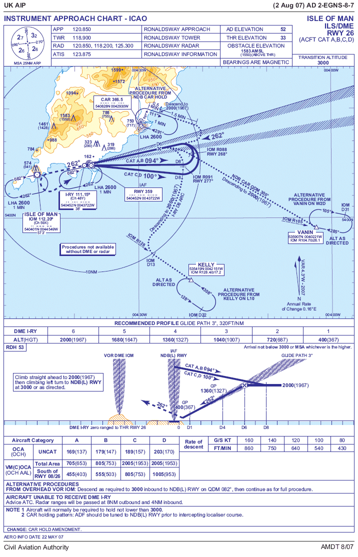
A while back minima used to be shown on approach plates - see above for the old Frankfurt plate which shows both the Decision Altitude (as it was called in those days) and the Missed Approach Procedure. Nowadays the UK have removed the minima and so this can be difficult for FS2004 users to find out. The Jepp/Aerad charts still give the data (airlines then factor this for local use) but you don't have to resort to searching these docs out to get your figures. I will explain..
A few years ago the CAA did not stipulate any approach minima and this allowed non company aircraft (business or private aircraft) to approach in far worse conditions than the airlines or charter aircraft (which were legally bound to publish minima for their pilots). A lot of other countries had already produced State Operating Minima and the CAA eventually did the same.
To search this out requires a bit more digging into the UK AIP. Ignore the approach charts and open up the Textual Data page for the airfield. Scroll down to Section 2.22 Flight Procedures and look for sub section 6 - Aerodrome Operating Minima for Non Public Transport Flights. This should give you the basic data you can go on.
For example at EGNS it gives for the ILS/DME 26 approach a DH of 250ft and minima of 700m RVR. If the glidepath is U/S and you are flying the Localiser/DME approach the DH is raised to 400ft and RVR to 1200m. A radar approach (SRA) has a much higher limit - 600ft - because it is deemed a non precision approach, as are NDB or VOR letdowns. If you look at Heathrow (and almost all other airports) the limits are much the same - 250ft for an ILS, 400ft for a Loc/DME and 600ft for most others.
The Missed Approach Point is shown on the approach plate but not for an ILS approach as it is redundant. This goes back to definitions so bear with me whilst I explain again.
Definitions
An ILS is defined as a Precision Approach Procedure. Because of this the terminology is slightly different in that the point at which the approach is terminated is called the Decision Height. Non Precision Approaches (VOR, NDB and Localiser only) use a different point called the Minimum Descent Height. There are subtle differences.
With the ILS the aircraft is allowed to descend to the DH (usually 250 ft) and, if the crew don't see the runway or approach lights they HAVE to execute a missed approach. In other words there isn't a MAPt for this procedure because it is the same point as the DH.
For Non Precision Approaches the aircraft can fly down to the MDH but then it is allowed to level off and remain at the MDH until it gets to the MAPt - only then does it go around. So, a MAPt (I'm adding the little T because the charts now show it as MAPt rather than MAP) is only necessary and shown for non precision approaches.
If you are wondering about the oddity of the non precision approach then let me explain. In the old days prior to DME becoming available a VOR or NDB approach was flown on timings only - pilots didn't have an distance information to show how close they were to touchdown. This still applies to airfields without DME too - it isn't a historical issue (look up the NDB plate for Cranfield).
The approach procedure was based on flying over the beacon at a set height and flying outbound for several minutes - the exact timing depending on your approach speed. You then turned inbound and descended to the MDH. If you got it right this would almost be like an ILS and you would reach MDH fairly close to the runway. However, if the wind was strong or unpredictable it could muck up the descent and you could easily find yourself at MDH with a mile of so to go - hence the need to stay at that height until the MAPt. You could play safe and reduce the descent rate to stop this happening but you could then be faced with the opposite problem in that you might still be coming down to MDH as the airfield appeared in the murk below you - with you too high to effect a landing.
So the MDH rule still applies to non precision approaches even though we have the luxury of DME to show us exactly how close we are to an airfield. This makes such approaches much more safe and accurate and you would think the DH rule could be applied to them but there is one more factor for keeping the MDH. Autopilots can track and ILS and they can be programmed to flag the DH and alert the pilots to land or go around. This still can't be done with a non precision approach. All you can do with a NPA is use the autopilot to fly the correct inbound heading but it can't be given any descent guidance. Therefore you just dial up the MDH and let it take you down to that height.