


FS2004 - VFR Map Reading
Part 1
Map reading? Are you SERIOUS??
Navigation in FS2004 is easy isn't it? All you do is set up a flight plan and get the autopilot to fly the route. If you are very brave you can dial up the navaids and hand fly the aircraft from beacon to beacon. That's how PPL's do it isn't it?
In fact the answer is no. Navaids are not part of basic PPL navigation training and pilots are still taught the same basic map reading techniques as Tiger Moth students in the 1930's. If you think this retrograde and out of touch with modern thinking then just ask any pilot who has suffered electrical failure if it's a silly idea..
What is Map reading?
Map reading is a simple technique in theory. You draw your route on a map and then verify your position during flight by comparing features on the ground with features on the map. That's the theory. In reality it requires a bit more paperwork before you jump in the aircraft but any real pilot will tell you that pre flight planning is worth it's weight in gold - you'll find you have enough to do once airborne. Enough of the chat - let's plan a real flight and show you some of the tools and tricks of the trade.
Note: This article is only concerned with map reading as applicable to FS. It is not intended to be suitable for real world procedures as it omits many sections of the proper pre flight planning schedule required. For the benefit of FS users intrigued by this statement real world pre flight planning involves more than just marking your route. It requires a full check on current and forecast route weather, NOTAM's, frequencies, navigation warnings, danger area activity and airfield procedures - most of which are not applicable in FS.
What do I need?
A real pilot requires quite a lot of items to plan a flight properly. The obvious one is a map but it is also necessary to have a map ruler, flight plan form, protractor, navigation (Dalton) computer AKA "whiz wheel", a kneeboard and a stopwatch. FS users are luckier because the only essential item is an aeronautical chart, but there is no reason why you cannot plan a flight with this real equipment if you have it.
To map read properly in FS you do require an appropriate aeronautical chart. In the UK there are two options - the "Half Mil" (because it's scale is 1:500,000) and the bigger scaled (and more detailed) 1:250,000 "Quarter Mil" chart. They can be obtained from any local flying club or UK aviation supplier - there are several online.
The half mil charts each cover a large area and there are just three for the whole of the UK. They are the more commonly used map for map reading by pilots but it takes a little practise to get used to reading them. That they are plastered with VOR rings, airways up to FL250 and all controlled airspace, danger areas and restricted zones doesn't help as the cluttered detail can be intimidating. Most real flyers still use them though in preference to the quarter mil series.
The better chart for map reading is the quarter mil. It is excellent and has plenty of detail for any map reading cross country flight. Of course, the scale means a smaller area covered and more maps to buy, but the CAA recently increased their size - the whole of the UK is now covered by eight quarter mil charts compared to the previous 18! If you ever feel like treating yourself then at least buy one of your local area - the scale is actually bigger than some road atlases and they are ideal for driving (especially since they have all the airfields marked on them).
Rather than have the whole big clumsy map to deal with here is your cut down section. Have a good look around it before you read on.
|
CAA
"Half Mil" map reproduced by kind permission. FS users who have not seen a half mil map before should take a little time to absorb the symbols used. Civil airfields are blue circles, military are red. Urban areas are yellow, forest green, high ground deepening shades of brown. In addition to the ground features the map can get cluttered with aeronautical detail but here you will only see a VOR rose at Gamston and small sections of controlled airspace (tinted pink and pale blue). |
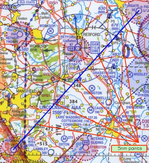
Hucknall
to Sturgate The
flight I have chosen for Part 2 of this tutorial is a short VFR hop from
Hucknall to Sturgate and the route has been marked on the standard CAA
1:500,000 chart. In addition to drawing a line I have also marked the
route at 5nm intervals - I will explain why later. Having drawn the line
a pilot can start work on the flight plan, entering track, distance and
safety altitude. With current route weather to hand the next stage is
to use the nav computer to calculate two essential items - heading and
groundspeed. FS users are luckier - they can print a flight plan direct
from FS2004 and save a lot of time and effort. The only item
missing on the FS plan would be safety altitude so let us consider this
- and see if you have really looked at the map properly. Starting at
Hucknall we can see a patch of high ground right of track at 515ft AMSL,
another at 472ft and a third at 384ft. A little further on we find some
masts - left of track at 516ft, right of track at 483ft and almost directly
on track at 676ft. This last obstacle is the highest so if we round it
up to 700ft and add 1000ft we have a safety height of 1700ft AMSL to work
with. For FS2004 this really is the only work required so we can now go
out to the aircraft and start the hard bit - the actual flying. To ease the
shock you are about to encounter let me just say a few things about what
maps show, what they don't show and what the best features are to look
for whilst flying. But
it doesn't look anything like the map! No
it doesn't! The first thing you will see are the fields - hundreds
and hundreds of them going right out to the horizon. In fact there is
so much to see that you can easily get confused on your first trip. There are only
a few features that will be of any real help in map reading and it is
only these that are drawn on the map. It may look rather blank as a result
but the real world will be full of detail. It is here that you have to
start training your eyes to ignore the inessential whilst looking for
the significant objects. Don't get dismayed if you find it hard at first
- we all do. It is a discipline we have never had any experience of before
so the brain has to be trained into being selective. This is the
point at which your own judgement can make your flight a success or disaster
and the simple rule is to look for the most prominent objects - ones that
stand out from the air so you can spot them easily. So what are they? The main distinctive
features to use are coasts, airfields, hills, masts, roads, railways,
forests or cities/towns. All are valuable in the right circumstances but
there may be reasons why it would not be wise to rely on them. Remember
that once you fail to spot an object you are looking for, or see an object
you didn't expect, the resulting confusion can easily lead to uncertainty
- not a good thing in flight! Let us look
at each feature and see their pro's and con's. Water
- The most obvious feature is the coastline,
you can't really ignore it! Ideal for following and distinctive if you
cross it. The only caveat is to beware of changes in shape between high
and low water - Morecambe Bay and the Wash are good examples in that large
expanses of sand at low tide completely disappear at high tide. Now in real
life the next best feature is a big body of water - reservoirs, lakes,
wide rivers - as you tend to see them because reflections catch your eye.
In the FS scenery they are just big pools of dead colour (unless you have
the new VFR Terrain scenery), no reflection and they will need a little
more care to spot. Despite that they are still identifiable and can be
very extremely helpful. Line
features - Dual carriageways
are also easy to spot but take care not to mistake them for a motorway
- they can look very similar from the air. Any other roads
you can completely forget - I mean this - because it is impossible to
identify a major A road from a B road or a farm track in some areas. Have
a look next time you fly around and note how tracks across farmland or
hills appear so prominently. Roads can also
get hidden by the trees or high hedges of a field boundary - very disconcerting!.
Unless you know the road well from driving down it don't use it for map
reading. Against railways
are the fact that they are less useable near busy junctions (try flying
over Crewe or Watford), they also disappear in cuttings or tunnels and
trees can again obscure the track (one reason why I got slightly lost
on my way to Shobdon many years ago). Use with care. Area
Features - Other
Features - Grass
strips can be very hard to spot from the air but so can bigger airfields
on a dull day. A blue circle with an inscribed cross indicates a disused
airfield and even more care is needed here. Many are still very evident
but some have faded back to farmland so effectively that only crop marks
reveal their former position. As with motorways and railways be careful
if there are a lot of airfields on your route (as in East Anglia) because
you can misident them so easily. Separating
the wheat from the chaff I
said earlier that the most eye catching feature you will notice once you
get airborne is the field pattern across the scenery. It takes a little
practise to ignore these and pick out the essential features listed above.
Look at this aerial shot.
Going
back to the points above it is obvious that the coastline is the prime
navigation feature here. Take this away and you have a rather more challenging
task to pick out detail - but this is where your learning begins. Can
you see any useful features in the photo above to use in navigation? The most obvious
feature above is the town at bottom left. From here you can see both a
road and a railway line run towards the larger town at the top of the
photo (not very obvious but that is what flying in haze is like). You
will also see that both road and railway disappear into trees after a
couple of miles and it becomes hard to identify them afterwards. The railway
is perhaps the easier - you can just about spot it running left to right
across the photo before curving round and fading into yet another copse
near the coast. You can clearly
see how dark the trees are in this photo although there are no areas large
enough to feature on a chart. Note also that in the centre of the shot
the trees border two rivers (which you therefore cannot see) that run
into two small bays at the coast. The clue here is the meandering line
of the trees and this is something you learn from experience. My only other
comment is that of high ground. The photo was taken at 4500ft and the
land at the top left corner of the shot has risen to 1500ft. It's not
that obvious is it? The
serious side Map reading
can be fun but, for a real pilot, it may have its bad moments. Although
not especially relative to FS I include the following to show why real
life can get a little more frightening than our sim and hope that users
may respect real world pilots a little more. When you are
reliant on map reading it is obvious that good visibility is essential
for peace of mind. A clear sky means that objects can be spotted a good
15nm ahead of the aircraft and this eases both mental stress and workload. If visibility
drops it significantly reduces the amount of information available
- it's no use using a huge town 6nm left of track for a position check
if you are in 5nm visibility and can't see it. Not only are you limiting
the features either side of the aircraft you are also going to spot features
ahead of you much later. If they appear on time this is no problem but
what if your expected feature isn't there? The non appearance
of an object may be due to several factors: 1. You
are flying slower than planned and it is still ahead. This sort of
problem will crop up in FS as much as real life but in FS you can pause
or switch on the GPS to ease your mind. In real life it is a far more
worrying situation because the aircraft is still trucking onwards and
you have to make decisions very quickly. Flying in such weather is possible
but can only be built up through experience - coupled with clear thinking
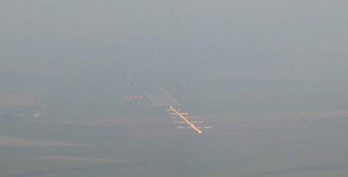
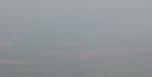
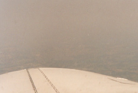
when things appear to go wrong. Even finding
an airfield is hard work. Below are two shots of an aircraft approaching
an airfield in poor visibility. You can see that without lights an airfield
is rather harder to spot!
Roads Motorways
are excellent features because they are highly visible. Be more careful
in using motorways when they converge or cross - it's easy to pick up
the wrong section.
Railways Railways
are also useful but you must use a map that shows all the disused sections.
Despite having faded out in Beeching's time many lines remain very much
visible from the air (many because of the trees planted along the tracks).
A long gentle curve followed by a straight run is typical of a railway
line - and they also cut randomly across field patterns.
Towns/Cities If
you are flying over the centre of Birmingham or London a map is going
to be of very little use <g> but elsewhere towns can become highly
valuable landmarks. Towns can have quite distinctive shapes and these
are quite accurate on aviation charts (always shown in hideous yellow
for some reason). If the town has a distinctive feature such as a railway
line, airfield or lake nearby so much the better.
Forests Forest
areas have unusual shapes and their dark colour can make them stand out
quite distinctly from the air. In real life pilots can sometimes confuse
the shadows thrown by isolated Cumulus as forest areas - something FS
pilots need not fear about unless this feature turns up in FS2012!
Hills Generally
hills are not very useful as a map reading feature. Once you reach 3000ft
you will be surprised how flat the terrain beneath you looks. It isn't
easy to detect variation in terrain unless it contrasts with the surrounding
countryside. An example would be Ely rising out of the otherwise flat
fenland.
Airfields Airfields
must be used with care. Many are marked on the aeronautical maps, both
active and disused, but not all are recognisable. A blue circle might
represent a large airfield like Manchester or Luton but it can equally
signify a small grass strip like Fenland or Sleap.
Masts Masts
are much harder to spot than you might think. They are most prominent
on clear sunny days and dangerously elusive in dull weather. Only use
masts if necessary i.e. there are no other features in the area to identify.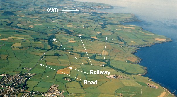
2. You are off track and the object is to port or starboard.
3. The object may be obscured by the nose of the aircraft as it
appeared out of the haze.