


Flight Planning
Theory versus Reality
As users become more involved in FS2004 and try to plan flights as close to reality as possible it can lead them down some rocky paths. In this tutorial I'll describe how to plan a perfect flight in the UK - and why doing this can still leave you unprepared for what may happen.
The flight details and photographs used in this article are based on an actual flight from Biggin Hill (EGKB) to Ronaldsway (EGNS) in a Citation C500 on April 9th 2005.

Stage 1 - Planning a flight
Most people use the FS Planner or FSNav/FSC to plan a flight. These are perfectly good for this as they show all the pertinent data - the airfields, navaids, airways and fixes likely to be needed for any flight.
The FS2004 planner goes one step further and tries to find a suitable route for a flight depending on whether you select low airways, high airways or off airways. It's not very good at this because it will always try to find the shortest possible route regardless of whether this is feasible in the real world. It's a good try but the planner just does not have the data necessary for correct route details in Europe. It doesn't know about one way airways, conditional routes, IFPS restrictions or others quirks of the real world system.
UK Procedures
In the UK we have an advantage in planning flights according to real world routes. The CAA have produced the UK Standard Route Document which will give you the correct airways routes between any two UK airfields or a UK airport and a UK Exit Point. This PDF file can be downloaded for free from the UK AIS web site.
If wandering through pages of data is not your cup of tea then there are alternatives. One is the Routefinder web site at http://rfinder.asalink.net/free/. Type in your airfields and it will give you a reasonable route to fly - but it isn't 100% accurate. It can throw out some strange routes or it may just give some rather basic data.
For
our flight from Ronaldsway to Biggin Hill we chose FL230 as the cruising
altitude and RouteMaster suggested:
EGNS DCT KELLY UL10 WAL STAR EGKB.
This is accurate if a little uninformative.
Even better is the excellent UK Route program by Graham Sumner that plonks the UK SRD data in a nice little interface. Again you type in the two airfields and it will throw up the correct UK routes relative to the level you wish to fly at. You may have to search for this program.
UK
Route will give similar output to Routefinder but it is a little more
helpful. In this case our flight gives:
EGNS DCT IOM L10 WAL ALKIN3L EGKB - which is absolutely
correct.
The Route
For the FPI flight plan the formal route given by UK Route above is correct and we did indeed file a flight plan with those details:
(FPL-N324JC-IN
-C500/L-S/C
-EGNS1400
-N0300F230 DCT IOM L10 WAL ALKIN3L
-EGKB0045 EGKK
-0)
For an FMS this could be programmed in directly but for FSNav and FS2004 planners you would need to dig a little deeper to find out the actual route for the ALKIN3L STAR for EGKB. The full route of this flight is:
IOM WAL PEDIG ROGBI CLIPY BKY BRAIN MAYLA SPEAR ALKIN
The STAR details can be found at the UK AIS site - complete with diagrams.
Stage 2 - Reality versus Theory

If you had plugged in to VATSIM or FPI and flown the above route accurately it would have been a perfect flight - in theory. The route is technically perfect and is, theoretically, what a real aircraft would have flown for that trip. Unfortunately reality is a bit different and here I will show you what actually happened.
The real flight from Ronaldsway to Biggin Hill and return was recorded. I had taken along an iPAQ4150 fitted with PocketFMS and this superb little tool saved the actual flight path to a breadcrumb file. This was ported to my PC and the track converted to JPG images for this article.
Real world procedure
We called for start up at exactly 1400 (rare to be on time) and we were cleared to A2 hold for rwy 26. During taxi ATC issued us with the airways clearance (EGNS doesn't have SID's so no clearance before start up). The clearance issued was "After departure a left turn on track for WAL, climb to FL70, expect FL230. Squawk 7426".
After take off we turned on course for WAL and called Manchester Centre who recleared us to FL110. The photo below shows us passing through 3500ft and on track for WAL VOR. Note that there is no full flight plan route loaded in the GPS - it simply shows a Direct To track to WAL.

The flight to WAL was exactly according to plan and after passing overhead the VOR we set course for PEDIG - the first portion of the ALKIN3L STAR into EGKB. We got as far as WHI NDB and then ATC gave us a radar heading of 170 to steer. At this point I switched on the PDA and it started to record our track as we passed abeam Ternhill.
You can view the subsequent track in Google Earth with the following KML file - GPS_N324JC.kml. Right click on this link and Save, then open in Google Earth.
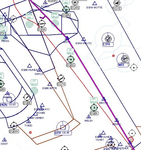
On the chart below you can see the actual track flown in red (it starts over EGOE) and the correct ALKIN3L STAR shown in purple. As you can see we never got anywhere near the correct route and the ATC radar headings actually took us west of the Birmingham TMA rather than to the east of it. Subsequent heading changes took us overhead Wolverhampton and then back towards the real STAR route.
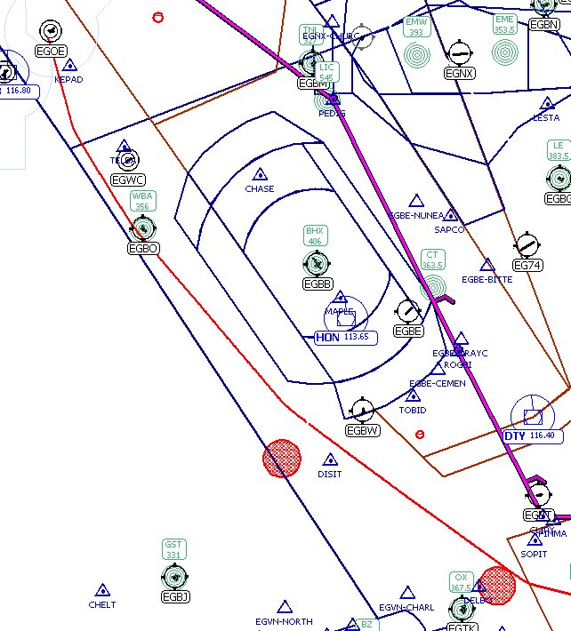
The STAR turns due east at CLIPY and you can see this on the screen above - CLIPY is just above the SOPIT fix. We never quite got to CLIPY although the radar headings gradually turned us more east as we approached the London TMA.
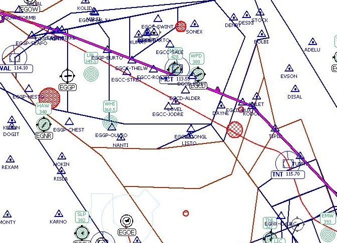
Time to show the next segment as you will see that we diverge even further from the STAR...
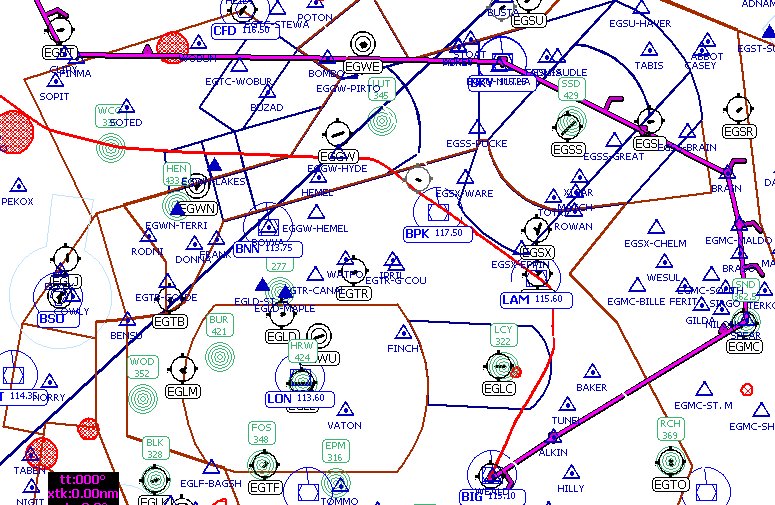
Having passed south of CLIPY the radar headings took us over WCO and then roughly parallel to the STAR. Had London City been busy I suspect we would have followed the extended routing but luck was with us and ATC kindly shortened the journey. As we passed south of Luton airport ATC vectored us southeast over both BPK and LAM and then turned us onto 180 to intercept the ILS for 21 at Biggin. You can see that this shorter route took us inside the extended zone for London City which allowed me to grab the shot below.

Review
You can see that no matter how carefully you plan a flight things can change significantly. European airspace is very dynamic and ATC are very flexible - they will shorten your journey if at all practicable. This is good news for cost conscious airlines but it can be slightly confusing for those of you trying to fly by the book in FS.
The trick is to retain flexibility. This isn't too difficult for pilots who plan flights with FS2004 or FSNav because it is easy to turn off the autopilot and accept radar headings from ATC. Those of you who have spent some time programming the flight into an FMS from such esoteric beasts as the PMDG 737TNG may find it harder to accept. You may find it a frustrating exercise to do all the programming only to see it blown apart once ATC start putting you on headings.
The truth is that you are still doing exactly the same as your real world counterparts. As much as you would like to fly the technically perfect flight it rarely happens in real life either. You have the luxury of turning off ATC to achieve this aim (I bet a lot of real pilots would enjoy this) but, if you combine FMS flight in a live ATC environment like VATSIM or FPI, you hit the same problem - ATC have traffic separation and expediency as their goals, not adherence to published procedures. Not a bad thing either as some STAR's and SID's can be horribly complicated and add all too many track miles to your destination.

Stage 3 - The return flight EGKB to EGNS
For the return flight the published routes are quite different and here again UKRoute had it perfectly right.
EGKB DCT DET DCT BPK N601 LESTA P6 RODOL L28 PENIL L10 KELLY DCT EGNS
Taking off from 03 at Biggin Hill points you directly into London City approach traffic so the SID requires a smart right turn after take off heading Southeast to pick up the easterly radial to DET. You can just about see this on the chart in the photo below.

As with the flight into Biggin the return flight deviated from the published route but not as much. Here is the initial departure segment through London TMA.
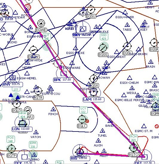
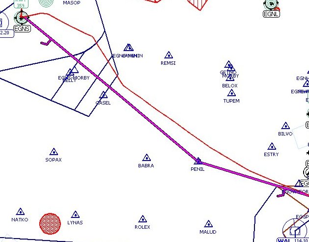
Approaching DET we were turned onto 040 for a short time and then sharply brought back onto course a few miles later. Just abeam LAM we were given a heading of 330 - effectively direct to Trent VOR. You can see that the track bypasses both BPK and LESTA.
Abeam East Midlands you will see that we turned left for a short time and then turned back to TNT VOR. This was our error having not heard the words "After Trent" in a clearance to "route direct to WAL". Easily corrected but it shows errors do happen.
Having corrected and flown over TNT the turn to WAL had only just been established when we were given a further radar heading that took us to the north of the VOR - actually to the fix at ASNIP (somewhat buried on the chart in the three fixes just north of EGGP.
After passing ASNIP we got a five degree left turn to swing us back into the airway and, halfway to PENIL, a correcting turn five degrees right. After handover to Ronaldsway approach you can see their initial vectoring to position us onto the ILS - a right turn onto 340 and then a left turn towards a 6nm final. During this stage we became visual passing 2800ft and elected for the visual approach.

Spooling down
For pilots who wish to fly as realistically as possible in FS there is no greater pleasure in obtaining real world data and planning to fly using this information. With UK Route this is entirely practicable - but it is only part of the whole process.
My suggestion is to use real world data whenever possible, especially in FMS equipped aircraft, as this will give you the experience in operating real world procedures and excellent practise in using the FMS properly. When you feel you have mastered both it is then time to introduce the more flexible world of real ATC. Here you can get pulled off your FMS planned route by radar headings BUT you still need to keep good situational awareness. It is in this environment that a pilot who can switch rapidly from FMS navigation back to conventional navaids - or reprogram the FMS with revised routes - is going to have the easier life.
ATC can put you on radar headings - easy to do as you just engage the autopilot in HDG mode - but they can equally tell you something like "route direct to BPK". The latter can give you a choice - use normal VOR navigation, use the GPS or reprogram the FMS. It's up to you to decide which is the easiest option but it is worth its weight in gold if you have practised all three.
For other photographs of this flight see my photography page.