

Kinetic SBS Utilities
Waypoint
Files
 |
|
Waypoint Files |
||||||||||||||||||||||||||||||||||||||||||||||||||||||||||||||||||||||||||||||||||||||||||||||||||||||||||||||||||||||||||||||||||||||||||||||||||||||||||||||||||||||||||||||||||||||||||||||||||||||||||||||||||||||||||||||||||||||||||||||||||||||||||||||||||||||||||||||||||||||||||||||||||||||||||||||||||||||||||||||||||||||||||||||||||||||||||||||||||||||||||||||||||||||||||||||||||||||||||||||||||||||||||||||||||||||||||||||||||||||||||||||
|
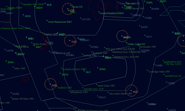
Waypoint files are used to add text to the BaseStation display. Typically waypoint files add airport names, navaids and intersections to the display. Sets of waypoint files are being created for each country. Each country can be highlighted in ADLite and will show the available waypoint types for the country (these can vary). Users can select all the files available or choose only those they wish to install. The list below shows currently available file sets and their data of validity. For more detailed information see Waypoint Set Details
|
||||||||||||||||||||||||||||||||||||||||||||||||||||||||||||||||||||||||||||||||||||||||||||||||||||||||||||||||||||||||||||||||||||||||||||||||||||||||||||||||||||||||||||||||||||||||||||||||||||||||||||||||||||||||||||||||||||||||||||||||||||||||||||||||||||||||||||||||||||||||||||||||||||||||||||||||||||||||||||||||||||||||||||||||||||||||||||||||||||||||||||||||||||||||||||||||||||||||||||||||||||||||||||||||||||||||||||||||||||||||||||||
|
Countries |
||||||||||||||||||||||||||||||||||||||||||||||||||||||||||||||||||||||||||||||||||||||||||||||||||||||||||||||||||||||||||||||||||||||||||||||||||||||||||||||||||||||||||||||||||||||||||||||||||||||||||||||||||||||||||||||||||||||||||||||||||||||||||||||||||||||||||||||||||||||||||||||||||||||||||||||||||||||||||||||||||||||||||||||||||||||||||||||||||||||||||||||||||||||||||||||||||||||||||||||||||||||||||||||||||||||||||||||||||||||||||||||
|
Waypoint
files for the UK correct to the UK
May 2011
AIRAC data. UK02
- Major Airfields
(Choice of airport names and codes and codes only) Note: Major Airports are supplied in two files. Major_Airport_Name displays the name and code for the airport but users who wish to reduce clutter can load Major_Airport_Code which will display the ICAO code only. Users should not select both files as active as this will simply duplicate data. Files can be turned on/off using the Settings, Data Files menu. |
||||||||||||||||||||||||||||||||||||||||||||||||||||||||||||||||||||||||||||||||||||||||||||||||||||||||||||||||||||||||||||||||||||||||||||||||||||||||||||||||||||||||||||||||||||||||||||||||||||||||||||||||||||||||||||||||||||||||||||||||||||||||||||||||||||||||||||||||||||||||||||||||||||||||||||||||||||||||||||||||||||||||||||||||||||||||||||||||||||||||||||||||||||||||||||||||||||||||||||||||||||||||||||||||||||||||||||||||||||||||||||||
|
Ireland Waypoint Data Waypoint files for Ireland. This data is correct to the Ireland Nov 2010 AIRAC data. Waypoints include: EI02
- Major Airfields |
||||||||||||||||||||||||||||||||||||||||||||||||||||||||||||||||||||||||||||||||||||||||||||||||||||||||||||||||||||||||||||||||||||||||||||||||||||||||||||||||||||||||||||||||||||||||||||||||||||||||||||||||||||||||||||||||||||||||||||||||||||||||||||||||||||||||||||||||||||||||||||||||||||||||||||||||||||||||||||||||||||||||||||||||||||||||||||||||||||||||||||||||||||||||||||||||||||||||||||||||||||||||||||||||||||||||||||||||||||||||||||||
|
USA Waypoint Data Waypoint files for the USA (including Hawaii and Puerto Rico). This data is correct to the FAA Nov 2010 AIRAC data. Waypoints are limited for now but include: USxx_02
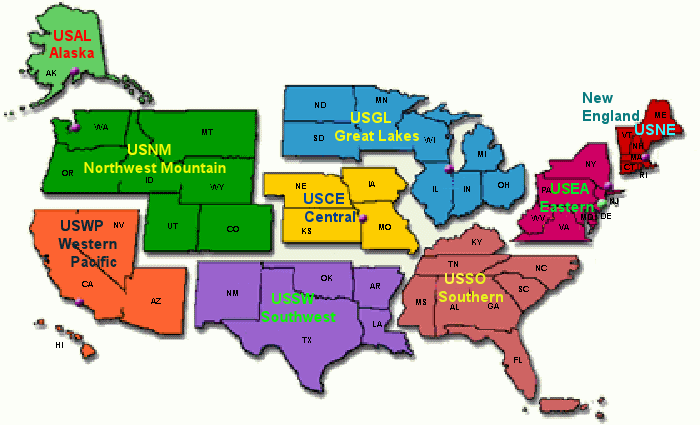
- Major Airfields IMPORTANT NOTES FOR US DATA The US data is vast and there are issues trying to load all the data into BaseStation. Please read the following instructions to avoid BaseStation grinding to a halt or locking up. To avoid excessive loading times I have split US data into the nine FAA regions as shown below:
The FAA regions, together with the included States, are:
Each of the nine regions contains a set of the waypoint files and I strongly advise users not to load more than one region at a time. Even with one region selected a refresh of BaseStation using the Reload option may take several minutes and the program may appear to have hung. Just be patient and they will load eventually. I recommend that users do not load heliports or minor airfields unless really necessary. If you do need them install the other files first, reload BaseStation and then install these two files one at a time. Screen clutter With all the above files loaded into BaseStation the screen can get swamped with airport names and codes. To avoid this I have produced alternative sets of all the files which will display the airport code only. To distinguish the files I have added a suffix to each. For example: USAL_02_Major_Airport_Name will display all major airports for Alaska showing full name and airport code. USAL_02_Major_Airport_Code will display all major airports for Alaska showing the airport code only. It is essential that users understand this naming convention and that they must choose one or the other of these files. They should not install both files as this will be a duplication of data. As some files are very large installing both will have a detrimental effect on BaseStation. Note for experience users: Users who understand the file structure above may recognise that they can mix and match between data sets. For example they can install major airport files that show name and code but opt for the code only files for the smaller airfields.
|
||||||||||||||||||||||||||||||||||||||||||||||||||||||||||||||||||||||||||||||||||||||||||||||||||||||||||||||||||||||||||||||||||||||||||||||||||||||||||||||||||||||||||||||||||||||||||||||||||||||||||||||||||||||||||||||||||||||||||||||||||||||||||||||||||||||||||||||||||||||||||||||||||||||||||||||||||||||||||||||||||||||||||||||||||||||||||||||||||||||||||||||||||||||||||||||||||||||||||||||||||||||||||||||||||||||||||||||||||||||||||||||
|
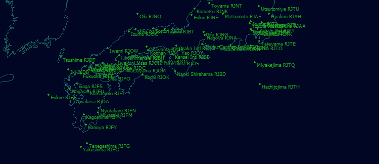
World-wide Waypoint Data Waypoint files showing Major Airfields are already available for most countries world-wide. Additional waypoint data files are under development and will be added to this page as they become available. It is hoped that further files for each country will released over time covering navaids and intersection data.
Latest
update - 28
Dec 2010 |


