SBS
- Google Earth Utilities
|
|
3D
Flight Logger for Google Earth
This
utility converts a recorded BST log file into KML files ready for
viewing in Google Earth.
Author:
Sean Johnston (Sejo)
Forum
Post:
3d Flight track producer for Google
Earth and
My next project - 3D flight path
viewing using Google Earth
Download
from: Forum
post.
Freeware
|
|
|
Live
3D Flight Tracker for Google Earth
This
JAR script converts socket output into KML files for live viewing
in Google Earth.
Author:
Varta
Forum
Post:
Fun with Google Earth
Download from: Forum
post.
Freeware
|
|
|
Squawkbox
A
multi purpose program providing squawk decodes, alerting on squawks
and a feed to display data in Google Earth.
SquawkBox
conveniently fits in the empty space at the top of the RadarBox
or BaseStation display which means that it is possible to access
all the functions of your RadarBox or BaseStation software while
SquawkBox is running.
Squawk
Decode - Squawkbox decodes codes and displays these (or
callsign) together with the allocated ATC service. The
program can read both live flight data on port 30003 and BST pre-recorded
flight data files as they are being created. You
can filter out squawk codes that you are not interested in.
Alerts
- Users can set alerts for a particular squawk code (or block of
codes). Alerts can trigger visual and/or sound alerts.
Google
Earth - Squawkbox can send port data to a KML file so
traffic can be viewed in 3D in Google Earth.
Author:
Andy Frost
Forum
Post:
Squawkbox
Download
from:http://www.gfrost.co.uk/SquawkBox/
Freeware


|
|
Track
Aircraft 3D
Track
Aircraft 3D is a lightweight and easy to use java application which
decodes Basestation SBS-1 output and allows it to be displayed in
Google Earth. The output to Google Earth supports colour coding
of aircraft depending on whether they are climbing, crusing or descending.
Display of 3D aircraft tracks is also supported
Author:
Simon Long
Forum
Post:
Track Aircraft 3D
Download
from:http://www.trackaircraft.com
Freeware
|

 |
|
SBS
- General Utilities
|
Polar
Diagram Plotter
This
excellent utility will capture SBS port data and record maximum
ranges aircraft are picked up for varying altitudes. It is ideal
for determining your SBS coverage and to check coverage variation
after upgrading your hardware.
Author:
Andy (Threemiles)
Forum
Post:
Polar Diagrams
Download from:
http://jetvision.de/sbs/
Freeware

|
|
ACARSD
1.7
ACARSD
is a free ACARS decoder that can also process Mode S data from SBS.
When first released ACARSD provided much additional data (including
photographs and routes) not available in BaseStation. Despite these
now being provided from other utilities ACARSD is still well worth
exploring.
Author:
www.acarsd.org
Forum
Post:
acarsd 1.70 RC3 Public
Download from:
Forum
post.
Freeware
|
|
PlanePlotter
PlanePlotter
is a network program designed to show aircraft from many SBS users
on a single display.

Author:
Bev
Website:
http://www.coaa.co.uk/planeplotter.htm
Payware
|
|
METAR Viewer
This
neat utility will give a decode of the current METAR data for a
selected airport. Just enter the ICAO code.

Author:
Ian Garton
Forum
Post:
METAR Viewer
Download from: Forum
post.
Freeware
|
|
Aircraft List Configurator
Moving
or changing data columns in the Aircraft List is a difficult procedure
involving rather painful editing of the INI file.
BS
Aircraft List Configurer (BS ALC) allows you to change the Aircraft
List order by simply dragging the columns into the order you want.
BS ALC allows you to add many of the columns that have not been
available in the Aircraft Listing by default - such as Operator,
Serial Number and PopularName (used by several programs for recording
and displaying Route data).
Author:
Stuart (acarslogger)
Forum
Post: BS
Aircraft List Configurer (BS ALC) v1.0
Download
from:
JetVision
Freeware
|
|
BS
ACARS Aircraft List v0.15
The
SBS3 SDR tuners can be used to monitor ACARS frequencies but Basestation
has not been adapted to process the received data..
Stuart
has written this neat little utility to fill the gap. By tapping
into the SQB database this aircraft list mimics the Basestation
Aircraft List display but will show ACARS derived data only.
Author:
Stuart (acarslogger)
Forum
Post: BS
ACARS Aircraft List
Download
from:
JetVision
Freeware
Click image for full size
|
|
BS
Recording Search
BS
Recording Search application enables you to extract certain records
out of a BST recording file and create a new smaller more manageable
recording file containing only the required records. After you have
run this program, the new file can then be played back using the
standard SBS-1 Basestation - Play Previous Recording option.
Records
can be extracted based on Mode S code, Callsign (Wild cards allowed)
or a specified time period. For each of the options above it is
then possible to 'speed up' the output so that when you play it
back it appears at 2, 5 or 10 times faster than the original speed.
Author:
Stuart (acarslogger)
Download
from:
JetVision
Freeware
|
|
BSTChart
BSTChart
allows users to open BaseStation recording files (BST files) and
view the flight data of all aircraft in the BST as a chart similar
to an FDR trace. The chart can be saved as a GIF or converted to
a KML file for viewing in Google Earth as a flat or 3D flight path.
The
Settings menu allows the display of aircraft information from your
SQB file, route data (taken from either FD or AD) and pictures if
stored on your HD. Altitude can be adjusted from a Flight Level
value to height AMSL if the QNH is known.
Author:
TG
Forum
Post:
BSTChart
Download
from: Forum
post.
Freeware
Click
on image to enlarge
The screenshot below
shows several Dublin arriving and departing flights exported from
BSChart into Google Earth.
|
|
SBS
Meter Lite/SBS Chart
SBS
Meter Lite reads BS socket output and displays blue LEDs representing
number of msgs/sec (MSG1 to MSG8). Updates every 5 seconds. SBS
Meter Lite can create a text log in the application folder. If enabled
then every 60 seconds SBS-1 Meter dumps data to the log as average
msgs/sec for the last 60 seconds for each type of MSG.
SBS-1
Meter Chart is a separate program that can read the data logs, either
historical data or in real time.
Author:
TG
Forum
Post:
SBS-Meter Lite
Download
from:
Forum post.
Freeware
|
|
BS
Photo
BSPhoto
reads the SBS socket output and displays photos from your HD (thumbnails
about 200 x 133 pix) of the 8 most recent aircraft detected. Supported
extensions: jpg (tested) and gif (not tested).
Up
to nine columns of aircraft can be displayed. The first column shows
all aircraft picked up by the SBS and the remaining eight can be
filtered to users preference.
Columns
can be filtered on ICAO code, Registration, User Tag, Mode S code,
Logo or Interested. Wildcards are accepted so a Mode S code of 43C
will display all UK Mil aircraft received..
All
user columns can be turned on/off as required. All filters can have
an audio alert set.
BSPhoto
can also show three additional displays.
Pressing
F2 will display a graph of the aircraft types and their frequency.

Pressing
F3 will display a graph of aircraft operators and their frequency.

Pressing
F6 will show a new photo panel which will display the aircraft (and
values) for the fastest and highest aircraft and those with the
greatest rate of climb or descent.
Author:
TG
Forum
Post:
BSPhoto
Download
from:
Forum post.
Freeware
|
|
Overflight
Logger
Overflight
Logger is an Excel spreadsheet that can watch for aircraft within
a specified radius of your SBS unit and can also log aircraft for
a separate defined radius. It produces graphs for Max Range, Max
% Horizon, Min Altitude and Min Elevation plus a 2D plot showing
lowest altitudes recorded.
Author:
DrAlan
Forum
Post:
Logging Overflights
Download
from: Forum
post.
Freeware
|
|
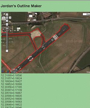
Jordan's
Outline Maker
A
drawing tool for creating outline files. The picture window opens
Google Maps and from this a line, or series of lines, can be drawn
and the code generated can be copied into an outline file.
The
program is ideal for creating airfield plans (if the Google map
resolution is good enough) but can also be used to draw coastlines,
roads or anyother map features.
Author:
Jef Pozkanzer
Forum
Post:
Airfield Plans - UK data
and
Tool to make outlines with Google maps ...
Web
Site:
http://www.acme.com/jef/outlines/
|
|
|
BSRoute
A
simple lookup program to return route information from an aircraft's
flight number.
Author:
Dogo
Forum
Post:
BSRoute
Download
from: Forum
post.
Freeware

|
|
BSAlert
BSAlert
is a stand alone Windows program that can notify you of a specific
Mode S code, a squawk or even blocks of squawks. BaseStation needs
to be running otherwise port 30003 data will not be received.
Author:
Dogo
Forum
Post:
BSAlert
Download
from: Forum
post.
Freeware

|
|
SBS-Resources
SBSResources
has been designed to make some of the add-on programs and data easier
to install. It also includes some additional material not available
online - particularly a set of high resolution and very highly detailed
airfields plans.
Author:
Rick
Butterworth
Forum
Post:
SBSResources
Download
from: Kinetic
Freeware
|