


SBS BaseStation
Article 4.1
 |


Aerial Location and Signal Reception
Overview
I am certain that all SBS users would like to have unlimited reception range for their systems but it's an ideal that few achieve. There are some immutable laws we can't overcome and some limitations our location imposes on us - but we can still make changes to improve our reception. In this article I will explain a little about aerials and their coverage and give some ideas about how to get the best out of our systems.
There are two major factors that govern our reception of Mode S transmissions.
|
1
|
Mode
S signals are line of sight and so we cannot pick up aircraft
below the geographical horizon. |
|
2
|
Mode S signals are blocked by any solid object between your aerial and the aircraft. In
effect this limits reception to your visible horizon - the
area of the sky you can see above any man made |
Keep these points in mind - I'll come back to them later.
Range
Maximum
range is limited by the curvature of the Earth. The higher an aircraft
is the further it will be seen and with airliners flying at a maximum
altitude of about 45000ft this will give us a maximum reception range
of about 240nm. Needless to say aircraft at lower altitudes will only
be seen at shorter ranges:
These distances aren't written in stone as propagation anomalies can vary the reception greatly. For example Liverpool is 76nm away from me and I shouldn't see aircraft below 4500ft overhead that airport - but I've occasionally picked up aircraft as low as 500ft on final. Likewise Dublin is 70nm distant and I have often detected aircraft on the ground there.
These effects are transitory (weather related) but every user may encounter them at times.
The maximum range I have detected an aircraft was 280nm away as it passed overhead Jersey. In truth I have also detected aircraft at much greater ranges (one showing up 760nm away) but if you get a signal like this it is inevitably a false signal, usually caused by the aircraft broadcasting incorrect Lat/Long data (it happens).
Limitations of reception
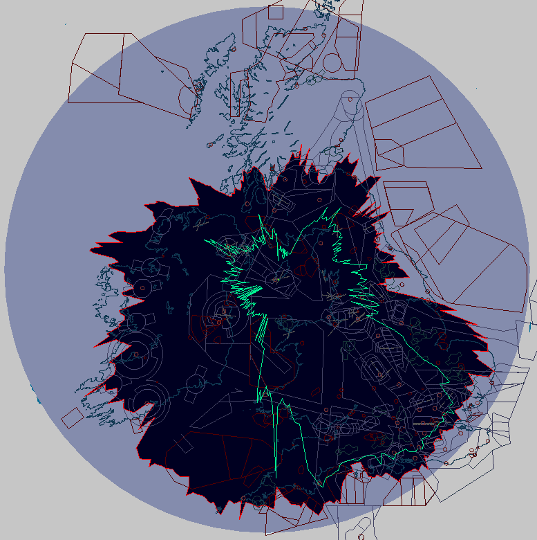
In a perfect world our SBS would pick up aircraft out to 260nm in all directions - a perfectly circular polar diagram. In reality we get a much smaller reception area - and not quite so circular. The screenshot below shows my nominal maximum range as a pale blue circle and my actual coverage as a dark blue area outlined in red - it is substantially smaller. My screen centre is shown by the bright green dot.
SBSPlotter was used to create the polar diagram over a period of several days. It doesn't give a truly accurate picture of my coverage because aircraft fly fairly set routes - there are some areas of airspace they may rarely fly in. For example aircraft west of Ireland tend to be Atlantic traffic moving east/west - it's exceptional to see an aircraft flying north/south in that area. The result is a more ragged polar plot in that direction.
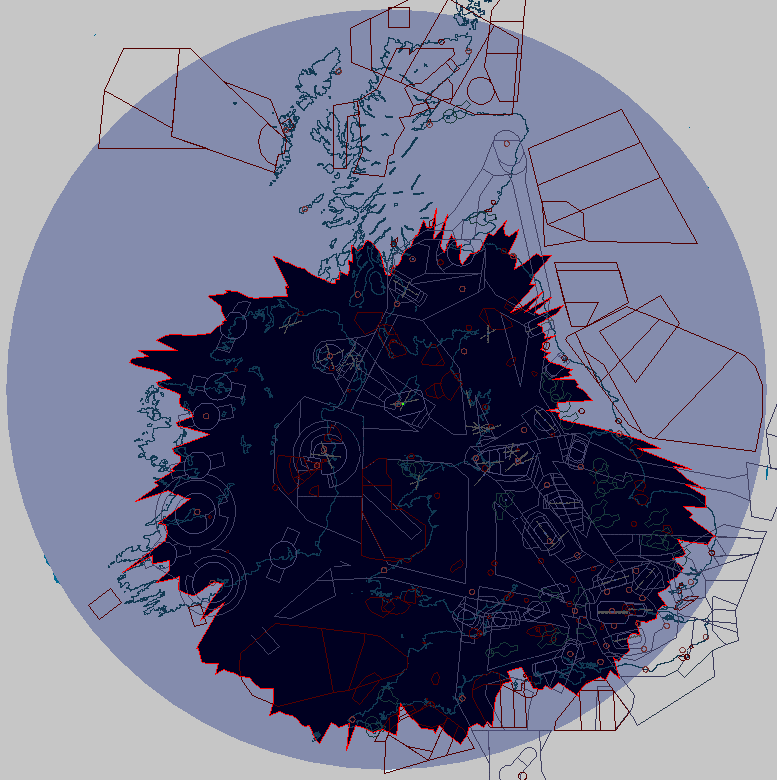
The screenshot shows that I am lucky in getting almost optimal coverage to the south but that it reduces significantly in other directions. To the north I barely get 100nm but even that would be considered good by some users. The reasons for this loss of coverage are twofold and I'll be describing each in detail below.
WYSIWYG
Used originally to describe graphic interface programs the phrase "What you see is what you get" is rather appropriate for Mode S signal reception too. Seeing is all important and anything that limits clear horizons is definitely not your friend.
I said above that geographical and man made obstacles can conspire against you and it is better to look at these separately. The former are effective over a grander scale and the latter are more localised.
Cruel Geography (with apologies to Sir Terry Pratchett)
Terrain can be bad news and it isn't just ranges of mountains that we need consider. Have a look at the following diagram - it's a real terrain cross section but with an increased vertical scale:
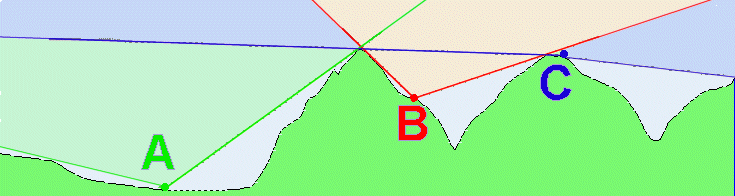
User A is on relatively flat land with hills to the east - which will severely limit range in that direction. Such a steep cutoff angle is bad news - if that slope was 45 degrees it doesn't take much calculation to see that an aircraft at 45000ft would only come into view at just 7.5nm range from the aerial.
To the west it looks like A has almost optimal viewing but even a small ridge as shown can cut maximum range. If the slope was just 3 degrees above the horizon (about the same slope an aircraft flies down an ILS) this would be sufficient to limit max range to about 150nm.
User B is in a worse position living on one side of a valley. Such a location would limit range to around 8nm to the west and maybe 20nm to the east. This is a true plot based on the location of one SBS user (Mr. Phil stand up please..)
User C is positioned on top of a hill and has almost optimum coverage. To the east he may actually experience slightly greater than nominal ranges because his aerial is looking down to the horizon. Range is all about those critical lower angles of coverage.
Note that although I talk about hills in the above diagram scale is not important. Coverage angles are the important thing here and the lower these are the better range you will get. Let's look at topography on a more local scale.
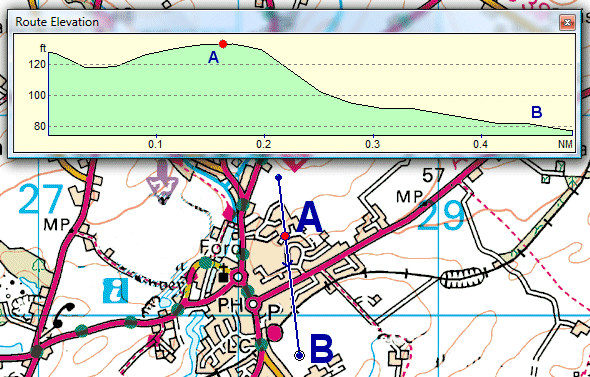
If you live in an estate built on a ridge then a house at the top of the ridge will have a clear advantage over a house built lower down the slope. In the diagram below a house at A - even though in the middle of the estate - has a coverage advantage over any other house in the area. Note that the heights are only varying by 40 feet or so - but it's still important. Local undulations of topography become as critical as any range of hills.
My polar diagram is a good example of terrain limitations. To the south I face over open sea so have a nominally perfect flat horizon. Hills to the west rise to 500ft about 4nm away and chop my range westwards to about 150nm. To the north the hills rise to 2000ft and so coverage is much worse - you can see that I only get about 90nm range in that direction.
You will also see that my range to the east (over Leeds) is sharply cut down to about 120nm - but that is where we move on to the second problem.
Neighbours
If hills aren't bad enough we must also look more closely at our immediate surroundings. Nearby objects can have more impact on reception because of their proximity than a range of hills several miles away.
Buildings and trees are the main culprits and it is why we also have to start talking about aerial position. There is little you can do to alleviate the effects of hills (other than move house) but you may be able to overcome localised effects by careful aerial placement.
Have look at this diagram:
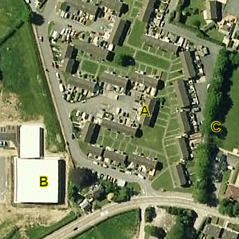 |
House (A) is in a residential location but has a line of trees (C) to the east and a group of larger buildings (B) to the southwest.
|
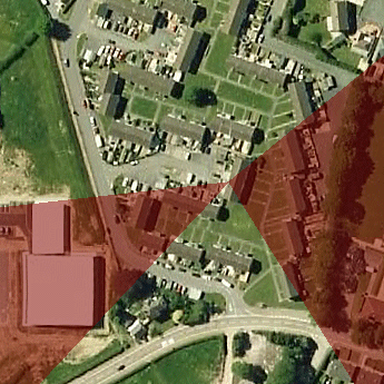 |
The banding shows possible loss of range owing to the height of the obstructions. The higher the objects the greater the limitations on detected range of aircraft. |
 |
The situation becomes more critical if an aerial is placed below roof level - say on a window ledge. In this case the adjacent houses (and your own house) create blind areas that will greatly limit reception. In this example the arrangement of the houses is especially detrimental. The darker the colour the worse the reception - based on proximity of objects. |
Going back to my polar diagram the limited range to the east is the result of a block of flats about 200m east of me. I can't show a photo of the area because they were built after the latest aerial shots on a well known mapping site.
Bonus points
Occasionally we can be lucky and find our ranges improve.
Trees - can be a pain but if they are deciduous then you may see a great improvement in range once they shed their leaves in the winter.
Weather - some users report changes in reception with varying weather conditions. We have to be careful here because sometimes it may not be as it may seem. Aircraft altitude is a case in point because aircraft do not transmit height above sea level. They send height relative to a pressure setting of 1013mb which is the value used to define Flight Levels. As pressure changes the indicated height will vary too and on some days it may look as though you are seeing aircraft at lower heights than you have come to expect - leading you to think your coverage is better when it really hasn't changed at all.
As an example if an aircraft is flying at 3000ft AMSL then his SBS indicated height will show 3000ft if the local QNH is 1013. If the QNH is 996mb then the aircraft will show an indicated height of 3500ft and if the pressure is high at 1030mb then the aircraft will show an indicated height of 2500ft. So if the pressure is high expect aircraft to show lower heights on screen - they may even show negative heights on the approach.
Ducting - Sometimes we actually get much better ranges owing to a transitory meteorological effect known as ducting. This can bend radio/radar waves and can result in us seeing or hearing aircraft well beyond our normal horizon. Ducting often occurs at very low altitudes and can result in you picking up aircraft on approach at an airport many miles away. I've picked up aircraft on the ground at Liverpool (76nm away) and at Dublin (66nm away). Ducting can last for just a few minutes or several hours. Further information on likely ducting conditions can be found at http://www.dxinfocentre.com/tropo_eur.html
Aerial Location
The limitation of an aerial in a window cannot be overstated. At the top of my page I showed a polar diagram of my coverage using an outdoor aerial. Switching back to an aerial placed in my first floor window produces a much more limited range (shown in green):
The loss of range is only one factor of reduced coverage. Aircraft count dropped from a peak period 150+ count to just 60 targets and local lower level aircraft were not seen at all. You can diagnose the above diagram and see that my house faces Southeast and that is where I retain best coverage. Northwest still produces some contacts despite signals having to pass through the building but large window area is probably a factor. As I live in a terrace it's apparent that the worst coverage is along the line of the terrace - NE and SW - I barely see 10nm in those directions.
Improving Reception
This very much depends on local conditions. Your surrounding geography is something you may have to live with but if you find it is local obstructions that cause more problems you may find that relocating the aerial will help.
Moving the aerial outside is the best option - one look at the diagram above illustrates this very well. With the aerial on my window I can't see traffic at Dublin but the outside aerial takes range well beyond Shannon.
If an outdoor aerial isn't an option (expense, local planning restrictions) then you should experiment with different locations inside the house. Aerial position can be quite critical and even on my window I can move it just 2" and see traffic level drop from 66 to 40. Try moving your aerial left or right an inch at a time until you hit a peak value - or raise or lower it. On nice days open the window and push the aerial outside.
The supplied magmount aerial works better with a ground plane. It is no secret that a simple biscuit tin lid can make a lot of difference if the magmount is placed in the centre of the lid. Give your other half the biscuits and she won't object to this odd contraption sitting in the window. Gary suggests that Quality Street or Roses works better but I'm not sure if this applies to the lid being more efficient or it being a more attractive bribe to your lady.
A further option is to consider moving the aerial up into the loft space. This is again subject to experimentation as roof tiles vary in blocking signal reception - some users may find no difference but others report a much better coverage. I used this system for a year and although it reduced coverage in my best direction (tiles are worse than glass) it more than compensated by providing much better coverage in other directions.
Hardware considerations
Moving the aerial up into the loft or outside the house raises other issues with hardware. My relocation to the loft meant moving the SBS unit too as the original aerial cable was only 3m long. Two and a half years later it is still up there - I give it a wave from time to time when I get sent up there to get paint brushes or Christmas decorations. If you don't like to see your box disappear you can also consider using a longer aerial cable run.
There are advantages and disadvantages to both options.
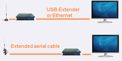
|
USB Extender
/Ethernet |
Setup - Magmount and SBS unit
in the loft. Up to 15m Cat5 cable running from the SBS unit to Advantages
- Cheap. USB can power the SBS if you have no power in the loft
(one cable only Disadvantages - Not really ideal for outdoor mounting but if you have a window in the loft you can move the aerial outside on good days. USB Extenders can suffer from dropouts caused by local EMF interference (Ethernet is better). You never see your SBS box unless you are a loftaholic. |
|
New
aerial
/cable |
Setup
- Replace magmount with a proper outdoor aerial and run the aerial
cable direct to the SBS Advantages
- Choice of a variety of good outdoor aerials to give better performance.
SBS stays on Disadvantages
- More expensive. Longer aerial cables result in greater signal
loss so high quality |
I am not going to delve into the murky waters of individual aerials or aerial cables. The choice is good and each has its supporters (and detractors). See various forum posts for users recommendations - you can even try building an aerial yourself.
If you are considering an outdoor aerial there are two essentials. First is to avoid any aerials that are made of mixed metals - they deteriorate rapidly in our climate. Second is the absolutely essential requirement to weatherproof all outside connections because it can be expensive to replace cables if water gets in. Leave some slack in the cables and seal all joints with amalgamated tape for ultimate peace of mind.
Formula Freaks
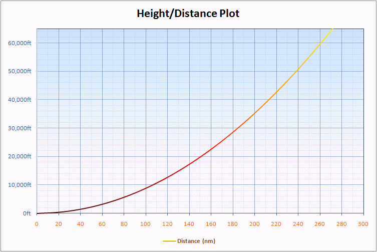
Users who like formula should note that I use the following formula for determining maximum range:
Distance
(st.m) = 1.2252 x SQRT(Aircraft Height in feet) or
Distance (nm) = 1.0647 x SQRT(Aircraft Height in feet)
This is a basic trigonometric calculation which corrects for the curvature of the Earth but does not make any adjustments for atmospheric refractions or other esoteric effects like ducting. It shows that an aircraft at 45000ft would have a visual horizon of 260st.m (225nm) and we could assume the same value as the maximum potential range of an aircraft at that height on our SBS.
For users who suspect that maximum range is limited by terrain or an obstacle it is possible to calculate the limited reception by adjusting the above formula. Three values are needed:
D1
- Distance from SBS aerial to hill or obstacle (NM)
H1 - Height of aerial AMSL (Ft)
H2 - Height of hill AMSL (Ft)
We
use the above to revise the numerical constant of 1.2252 by using the
following formula:
SQRT(D1 / SQRT(H2 - H1))
For example say we have an object at 3000ft (H2) and 60nm (D1) from our position. We therefore get:
SQRT(60 / SQRT(3000)) = SQRT(1.0954) = 1.0466
As
the resulting value is less than 1.2252 it shows the hills do indeed limit
reception. If the value was greater than 1.2252 it would suggest the object
does not lie in the reception plane. Replace the original 1.2252 with
the revised value of 1.0466 in the original formula to give
Distance
(nm) = 1.0466 x SQRT(Aircraft Height in feet).
So, for an aircraft flying at FL225 (22500ft) a user with an unlimited horizon should see it to a maximum range of:
=
1.2252 * (SQRT 22500)
= 1.2252 * 150
= 183.78nm
For the user with terrain limitation the result would be:
=
1.0466 * (SQRT 22500)
= 1.0466 * 150
= 156.99nm