


SBS BaseStation
Article 4.5
 |


Polar Plots SBS-1 v SBS-1e
Overview
This article is intended to show comparative reception of the original SBS1 unit and the new SBS1e receiver. I post these shots with slight reservation because the comparison is not entirely balanced.
Measurements
1. Both plots were taken from data captured by SBSPlotter but over differing time periods.
2. The time period for the SBS1e recordings was truncated when a Windows Update stopped SBSPlotter working.
3. During the time the SBS1e plot was running traffic flows were different. The SBS1 plot was taken in Summer and the SBS1e plot in Winter.
Plots were taken using identical aerial and computer equipment. The SBS1 unit was unplugged and replaced by the SBS1e keeping the rest of the system untouched. The only change was that the SBS1e required an additional connector to plug the aerial cable (BNC connector) into the SMA socket on the unit. This may have resulted in slight loss of signal on the SBS1e.
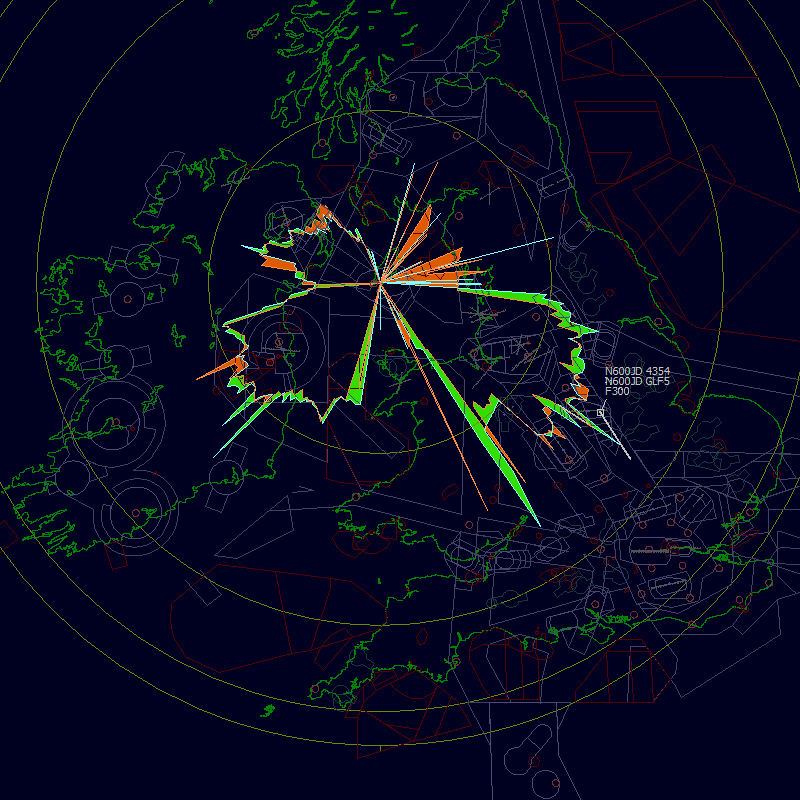
The plots show both the SBS1 and SBS1e maximum ranges at various height bands. Range rings are set to 100nm, 200nm, 250nm and 270nm - the last being the theoretical limit for reception of an aircraft at FL470.
Where the SBS1e exceeded SBS1 ranges the areas are filled green. Red areas show that the SBS1e range was less than the SBS1 plot.
Above FL300
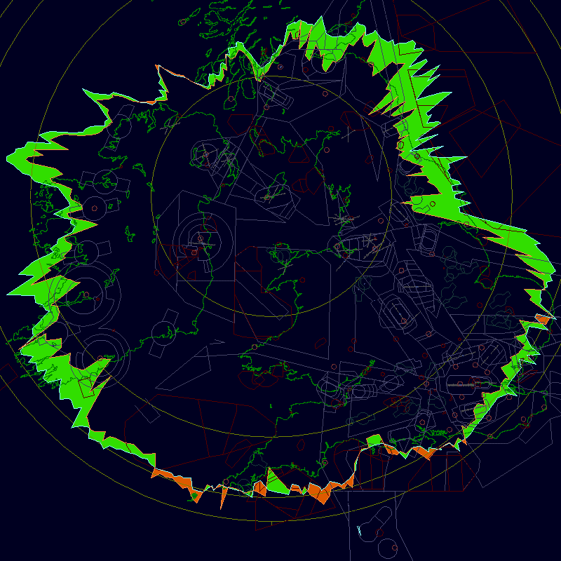
The plot shows that for high level traffic the SBS1e generally saw greater ranges - especially so east and west. To the north coverage is limited by a range of hills about 10nm from the aerial so I expected to see no improvement. To the south I am getting almost optimal range on either unit and I am sure the SBS1e would have captured greater distances had the plot run for a longer period. I do not consider the SBS1e has poorer performance in this direction - the results being more related to traffic flows.
Coverage to the east showed the most marked increase. It may not be coincidence that in this direction my range is limited by nearby buildings rather than distant terrain.
FL200 - FL300
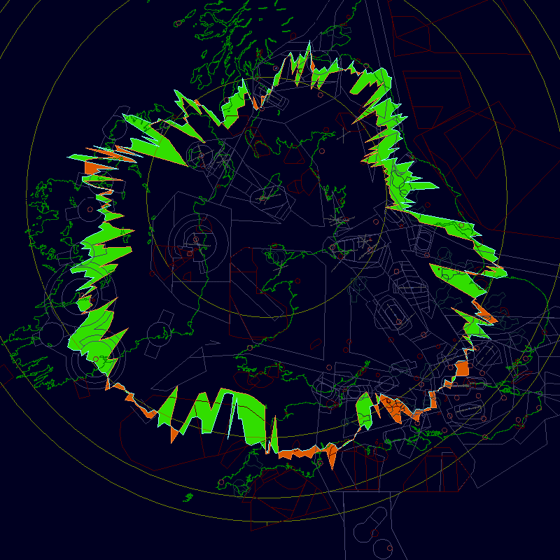
This plot shows similar results to the higher level plot but with a nice increase in range south of Wales. Max range for an aircraft at FL300 is about 230nm and I am getting close to that to the south.
FL100-FL200
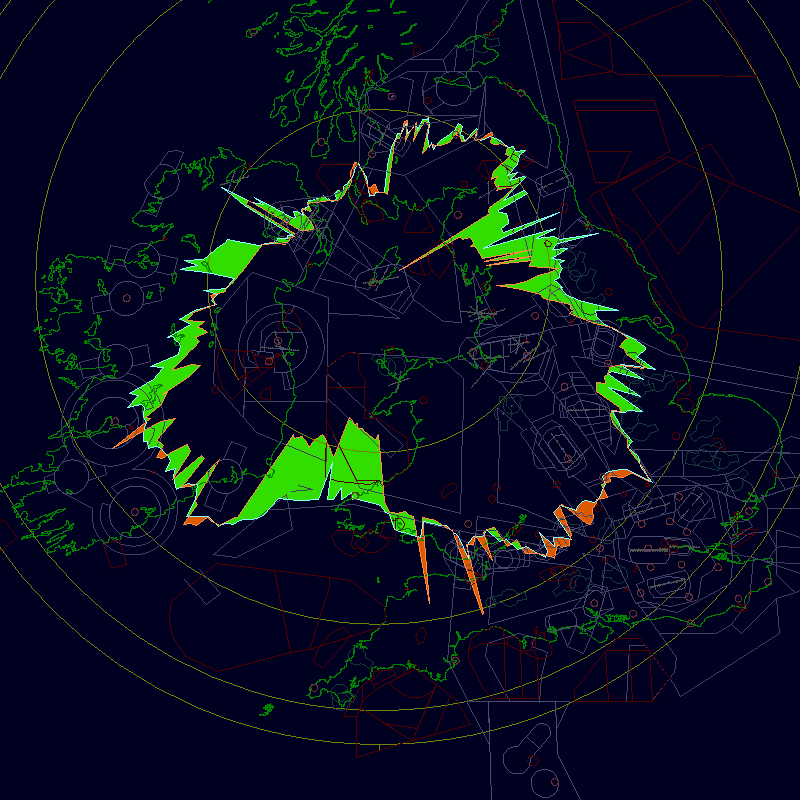
Generally less proportional increase over the high level plots although easterly coverage still shows significant improvement. The huge increase towards Strumble matches improvement seen on the previous plot. Max range from an aircraft at FL200 is about 174nm and I am close to that limit to the Southeast (using either box).
Below FL100
Possibly the most useless plot. There is very little ADSB traffic in the Irish Sea at these levels (too many Danger Areas) so solid contacts are limited towards Dublin, Belfast and Manchester. I do not think there is enough data here to warrant any meaningful analysis. At FL100 maximum range should be about 125nm so I suspect some of the longer plots past Birmingham may well be spikes. Users centred near an airport with a high level of ADSB traffic would probably be able to generate a far more worthwhile plot - it is obvious that no ADS-B aircraft landed locally during the time the plot was run.
Conclusions
Generally the SBS1e outperformed the SBS1 on distance. I didn't expect any greater ranges to the south as I get almost optimal theoretical coverage in those directions already and increased unit sensitivity isn't going to help see any further over the horizon.
The most marked increase in coverage is to the east and west. It may be coincidence but in those directions my coverage is limited by local buildings rather than by distant terrain. This may indicate that users with nearby obstructions may (I'm not going to suggest it will) gain extra range more than users who are limited by terrain issues.
Traffic below FL100 is very sparse in my area and I do not consider the final plot of any real value.
The SBSPlotter output file gives distances for each degree point. I added all these values up and divided by 360 to give average range for both plots. The results gave:
|
Height
Band
|
SBS1
|
SBS1e
|
Increase
|
|
Above
FL300
|
178.0239
|
189.8083
|
+6.62%
|
|
FL200
- FL300
|
142.4092
|
154.6564
|
+8.60%
|
|
FL100
- FL200
|
105.9714
|
116.2408
|
+9.69%
|
|
Below
FL100
|
49.6475
|
49.3039
|
-0.07%
|
On average I could therefore say that I saw an 8.28% increase in range from switching to the SBS1e. It would probably be higher if data below FL100 was more abundant.
Increased sensitivity of the SBS1e doesn't just mean better ranges - it should also pick up weaker targets within a user's polar coverage. Although I suspect that observed traffic volume is higher on the SBS1e I have no means of confirming this.